Geologic Overview
Missouri is situated on an ancient geologic structure called the North American Craton, which is the core basement rock forming the North American continent. Basement rock is the rock that forms the core of all continents, and in Missouri, this basement rock was first pushed into the North American Craton by tectonic forces to form what would become the base of Missouri. Additionally, bedrock, which is the layer above the basement rock, was added to the craton over the course of geologic history. Bedrock is not sediment; rather, it is dense, hard rock, most often igneous or metamorphic. It is sometimes exposed on the surface, but it is typically hidden by layers of dirt and sediment hundreds or thousands of feet thick. Missouri contains each of the three classes of rocks that forms the basement rock and bedrock: igneous, metamorphic, and sedimentary rocks. The most common igneous rocks in Missouri are rhyolite, granite, diabase, and volcanic tuff, each of which can be seen exposed in the St. Francois Mountains. Metamorphic rocks are formed when rock changes because it is subjected to different extreme conditions that have the potential to morph rocks, including high pressures and temperatures. Metamorphic rocks are rare in Missouri, and they are usually only found in basement rock. The only partially exposed examples in Missouri are the Hawn Park Gneiss found in Hawn State Park (and there is debate as to whether or not this rock is actually metamorphic), and some samples housed in glacial sediment in Northern Missouri. Sedimentary rocks are very common in Missouri, as many cycles of ocean rise and fall deposited sediment across the basement rocks, most often leading to limestone formation. Sedimentary rocks are formed by a very long process of erosion and compression. As weather conditions erode existing rocks, grains of sediment collect and are carried to a sediment deposit, often by means of water or glacial transport. In large basins of sediment, which often are found in areas such as river bottoms, depressions in the Earth, and lake bottoms, layers of sediment gather over a large period of time. Gradually the initial layers of sediment are subjected to pressure and chemical reactions due to the sediment above. As water between the sediment is pressed out, the grains of sediment bind together in a process called lithification, which forms the sedimentary rocks (Spencer 2011).
Geologic Structures in Missouri: Folds, Joints, and Faults
There are several common geologic structures in Missouri. One such structure is a fold, which forms because sedimentary rocks bend under pressure rather than breaking immediately. Tectonic pressures from continental collisions during the Pennsylvanian Period (which simultaneously created the Appalachian Mountains) caused the layers of rocks to bend into the folds in Missouri. Folds are seen in road-cuts in the layers of rock in two orientations: either domed upward (an anticline) or downward (a syncline). In the event when rock cannot respond by bending into folds because forces are too sudden or powerful, the rock breaks, forming structures called joints. There are two major orientations of joints in Missouri: Northwest-Southeast and North-South. Joints and fractures are sometimes hard to distinguish, but due to erosion, the joints are widened and filled in with dirt and sediment, making the joints more visible as time passes (Spencer 2011).
Elephant Rocks State Park in southeastern Missouri exhibits the effects of rock fractures well. While initial cracks formed in the granite as it cooled over 1 billion years ago, during periods of continental uplift over the course of Missouri’s history, the larger cracks formed in the rocks, fracturing all of the underlying granite into cubes. As the rocks were slowly uplifted and exposed at the surface, wind and rain slowly eroded, rounded, and enlarged the fractures to produce the large oval shaped boulders that are known as the Elephant Rocks (Seeger 2008).
Below is a picture of one of the “elephants”:

Richard Hathaway, October 2015.
The next picture displays an intersection of two rock fractures (a faint fracture oriented vertically and a more eroded fracture oriented horizontally). The rocks below will someday look like the rock above after enough uplift and erosion.

Richard Hathaway, October 2015
Faults are formed from fractures of joints when large tectonic forces pressure the fractures in the rock for long periods of time, which can result in the rocks slipping past each other in what is called a fault. There are three types of faults: transverse (sliding horizontally), normal faults (top rocks slide down), and reverse (upper rocks slide up) (Spencer 2011). The most notable fault feature of Missouri is the New Madrid Seismic Zone, found in the southeast corner of the state. This zone was responsible for the famous 1895 and 1811-1812 earthquakes (USGS 2015).
Brief Timeline
Timeline of Missouri Geologic History:
- 1.8 Billion Years Ago – 1.3 Billion Years Ago – Baserock of Missouri forms as volcanic eruptions occur on the southwest coast of Laurentia.
- 1.1 Billion Years Ago – 750 Million Years Ago – Missouri is part of the supercontinent Rodinia.
- 542 MYA – 488 MYA – Cambrian Period – First major sea Paleozoic sea level rise, the Sauk Cycle, begins. Oldest known sedimentary rocks deposited in Missouri.
- 488 MYA – 444 MYA – Ordovician Period – Tippecanoe Cycle of sea level rise begins – Large amounts of dolomite deposited. Rise of Ozark Dome begins.
- 444 MYA – 416 MYA – Silurian Period – Northwest section of Missouri submerged – volcanic activity at the edge of North America renews seismic activity across the state.
- 416 MYA – 359 MYA – Devonian Period – Kaskaskia Cycle of sea level rise begins; sea covers much of the state.
- 359 MYA – 325 MYA – Mississippian Period – Shallow sea covers Missouri but drains by the end of the period.
- 325 MYA – 299 MYA – Pennsylvanian Period – Pangea formed. Appalachian and Ouachita Mountains created. Frequently fluctuating shoreline due to Absaroka Cycle of sea rise creates large swamps and deltas across the state and deposits a mix of shale, limestone, sandstone, and mud.
- 299 MYA – 251 MYA – Permian Period – Missouri lays above sea level, causing much erosion.
- 251 MYA – 200 MYA – Triassic Period – Missouri continues to sit above sea level. Pangea moves northward.
- 200 MYA – 145 MYA – Jurassic Period – Zuni Cycle of sea level rise begins. Missouri is probably a coastal area.
- 145 MYA – 65 MYA – Cretaceous Period – Sea continues to flood Missouri – to what degree is unknown, but most likely covers at least the Mississippi Embayment.
- 65 MYA – 23 MYA – Paleogene Period – Tejas Cycle begins; ocean floods southeastern Missouri for the last time.
- 23 MYA – 2.6 MYA – Neogene Period – Missouri dry. Ozark Dome continues to rise. Mounds Gravel is created.
- 2.6 MYA – 11,000 Years Ago – Pleistocene Epoch – Ice advances from the north into central Missouri and then retreats. Modern Missouri and Mississippi Rivers formed as glaciers melt.
Timeline source: Spencer 2011.
Reflecting on the timeline, a couple of interesting facts emerge that illustrates the enormous length of history that Missouri possesses since its “birth” 1.8 billion years ago with the first igneous rocks. For over 70%, of Missouri’s history, from 1.8 billion years ago to 542 million years ago, the state was composed of solely igneous rocks. For about 20% of Missouri’s history, the state was a part of the supercontinent Rodinia. However, all of Missouri’s history has taken place within the last 40% of Earth’s history as the Earth formed 4.6 billion years ago, and all of Missouri’s geologic history except for the igneous events occurred in the last 12% of Earth’s history, from the Cambrian Period onward. (Statistics based of information from Spencer 2011).
Below is a diagram that places other worldwide geological events on a timeline that helps put into perspective the localized events in Missouri described above.
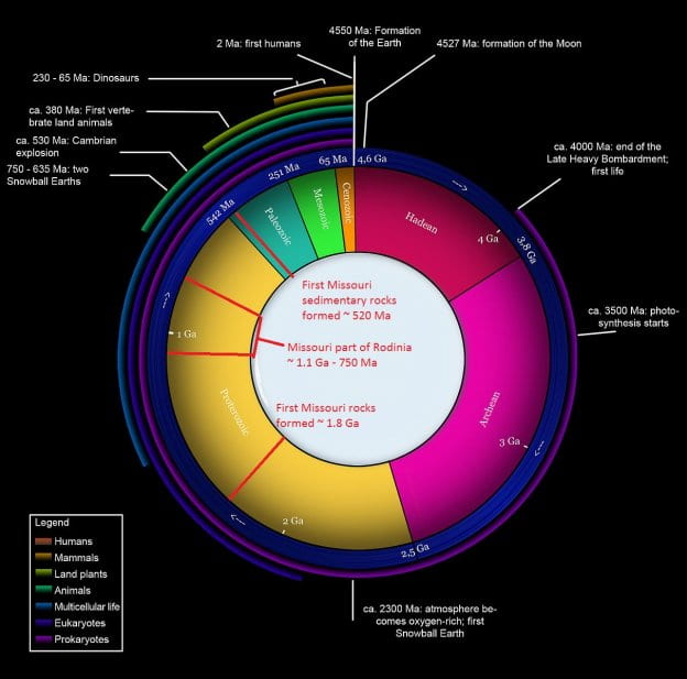
Note: Image edited to include information about Missouri.
Image Source: Wikimedia Commons, Woudloper, September 2007, https://commons.wikimedia.org/wiki/File:Geologic_clock.jpg
Geologic History:
Proterozoic Eon – 2.5 billion years ago to 542 million years ago
As mentioned above, the basement rock of Missouri was formed about 1.8 billion years ago as outlying volcanic islands began to crash into the southwestern edge of the ancient continent of Laurentia, also known as the North American Craton, due to tectonic forces pushing the islands into the continent. The resulting subduction and volcanic activity formed the igneous baserock that now lies across much of central and northern Missouri. About 1.5 billion years ago, the basement rock in southern Missouri was formed due to a series of large volcanic eruptions on the south coast of Laurentia. Rather than volcanic eruptions induced by tectonic subduction, these igneous rocks were formed by a rising magma plume from the mantle that erupted out of magma deposits in a series of huge volcanic eruptions. As the magma moved beneath the crust, it flowed along two older fault zones, the Grand River and Central Missouri Tectonic Zones, traversing central Missouri in a Northwest-Southeast orientation. The area between these two faults is the called the Missouri Gravity Low, an intriguing geological structure in that this stretch of granite is less dense than the surrounding rocks on either side of this area. The Missouri Gravity Low is 370 miles long and 60 miles wide. The last set of rocks to be formed in Missouri formed about 1.3 billion years ago, as more magma flows in Southeastern Missouri surfaced and hardened into diabase (Spencer 2011).
There are two major types of igneous rocks present in Missouri: granite and rhyolite. Granite is formed from magma that cooled under the surface of the Earth and did not erupt. Because it did not erupt and cooled more slowly, granite contains large amounts of mineral crystals. On the other hand, rhyolite is formed from silica rich magma that erupted explosively and then quickly cooled. Crystals do not have as much time to form when the rock cools and hardens quickly, so rhyolite does not have as many large crystals as granite. Because of the high silica content, the magma contained a lot of explosive power, thus leading to the conclusion that the eruptions that formed the rhyolite of the St. Francois Mountains were among the most intense volcanic eruptions on Earth (Seeger 2008).
Granite and rhyolite erode and weather at different rates. Granite’s crystal and larger mineral structures are easier to break apart than the harder, more solid structure of rhyolite formed from its fast cooling, so the granite erodes faster. In the St. Francois Mountains, rhyolite can often be found in the higher areas because it erodes less, while granite is found in the lower areas of the landscape because it has eroded and weathered away (Seeger 2008).

Richard Hathaway, October 2015. Exposed granite on the Johnson’s Shut-Ins Scour, formed during the Proterozoic Era volcanic eruptions.

Richard Hathaway, October 2015. A dislodged piece of rhyolite on the Johnson’s Shut-Ins Scour.
A third type of igneous rock found in Missouri is called volcanic tuff. Tuff is formed in very intense explosions by small pieces hardened magma called volcanic ash that bind together upon impact with the ground (Seeger). Below is an outcrop of volcanic tuff found at Johnson Shut-Ins State Park. Note the distinctive bands of brown coloring among the mostly black colored rock.

Richard Hathaway, October 2015.
Rock formation during the end of the Proterozoic era was very limited; however, geological processes were still present in Missouri. Between 1.1 billion and 750 million years ago, other continents joined with Missouri and the North American Craton, forming the gigantic landmass Rodinia. After Rodinia broke apart 750 million years ago, another tectonic rift almost managed to break apart the entire craton. This fault zone still exists today, buried below Southeastern Missouri, and this fault still causes substantial earthquakes in Missouri today. Scientists also believe that between 850 and 635 million years ago, there was a massive ice age covering all of Missouri, and some scholars even think that it is possible that the entire ocean froze as a massive ice sheet covered the entire planet. Due to the ice, the entire North American continent was eroded down to a land mass of relatively equal elevation, with only some of the igneous hills remaining. When the ice melted at the end of the ice age, the waters inundated the entire continent and brought with it the first of Missouri’s sedimentary rocks (Spencer 2011).
Paleozoic Era – 542 to 251 million years ago
Many more of Missouri’s sedimentary rocks were deposited in the Paleozoic Era from 542-251 million years ago during periods of rapid cycles of high sea level rise and fall. Six cycles of sea level rise and fall occurred during the Paleozoic Era, and each rise and fall brought a new round of sedimentary rocks. As the seas receded with each cycle, the newly formed rocks were exposed and eroded from weather and the air, creating clear distinctions between layers of rock from each cycle. While there are hundreds of smaller factors of sea level change, the main cause is tectonic activities at the ocean floor. During periods of high tectonic activity at the ocean floor, large amounts of igneous rock are formed from magma being pushed up through deep sea vents. This process creates ocean mountain ranges over time, which displaces water upwards and causing the sea level to rise (Spencer 2011).
Cambrian Period – 542 to 488 million years ago
From the beginning of the Cambrian Period to the present day, there have been six major cycles of sea level rise. The first cycle, called the Sauk cycle, began in the early Cambrian Period. At this time, Missouri and the rest of the North American continent were located at the mid-southern latitudes. The flooding waters deposited large amounts of sand, which formed into sandstone under pressure. Because these are the first rocks to form in Missouri since the igneous rocks in the Proterozoic Era, the distinction between the sandstone and the underlying igneous rocks represents a geological gap of 900 million years. This separation between these layers in Missouri is known as the Great Unconformity, an important feature of Missouri’s geological history. Additionally, Missouri’s oldest known sedimentary rock layer, the Lamotte Sandstone, about 520 million years old, was deposited during this period. As waters inundated Missouri in the Sauk Cycle, the weathered rhyolite hills that were formed in the Proterozoic era became isolated islands, but also were soon flooded and covered in sandstone (Spencer 2011).
The Johnson Shut-Ins scour reveals the effects of the rising sea on the rhyolite and granite. A mixture of rock called conglomerate outcrops on the scour, consisting of bits of old rhyolite and granite joined together by layers of sandstone. This is an interesting formation considering that the rocks mixed in the conglomerate were formed 900 million years apart from each other (Seeger 2010).

Richard Hathaway, October 2015. An outcrop of conglomerate at the Johnson Shut-Ins scour. This area once used to be a ancient beach during Cambrian times (Seeger 2010).
The ocean also began to deposit carbonate sediment in the form of calcite (a mineral containing calcium and carbon) and dolomite (very similar to calcite, but magnesium takes the place of roughly half of the calcium atoms), which had begun to collect on the sea floor, having been ejected by small organisms and plants. Carbonate rocks, specifically limestone and dolomite, formed from calcite and dolomite minerals and represents a large portion of the Cambrian rocks from Missouri. An intriguing observation is that a substantial portion Missouri’s oldest carbonate is actually magnesium based dolomite instead of the calcium based limestone. This is odd because limestone is much more easily formed than dolomite because calcium is more easily used by organisms in the ocean, and there isn’t enough magnesium in the water. One hypothesis to explain this observation is that the dolomite was created as limestone and then converted to dolomite over history. Thus, some of the initial limestone was transformed over time into dolomites as magnesium from the surrounding environment, possibly from flowing water or from magma deep in Proterozoic igneous rocks, created fissures in the carbonates that allowed magnesium to infiltrate the rocks (Spencer 2011).
Below is an outcrop of dolomite of Cambrian age in the Johnson Shut-Ins scour (Seeger 2010).

Richard Hathaway, October 2015.
There are five main layers of Cambrian sedimentary rock. After the Lamotte Sandstone was deposited, the next overlying layer of rock is called the Bonneterre formation, which is comprised of dolomite and limestone. Because the entire state was not yet submerged when the Lamotte Sandstone was deposited, as some of the rhyolite hills were still exposed, Bonneterre rocks sometimes lie directly on top of igneous rocks, and these rocks lie across most of the state. Additionally, Bonneterre rocks are important because a large amount of the state’s lead has been mined from these rocks. The third layer of sediment to be deposited is the Davis formation, which due to frequent minor sea level changes, contains alternating layers of limestone, shale, and sandstone. Additionally, the Davis formation contains evidence of numerous different ancient marine fossils. The fourth layer is the Potosi formation, which is made up of carbonate layers. Finally, the top layer of Cambrian rock is called the Eminence formation, which is formed from dolomite and contains a large amount of chert. Additionally, the Eminence formation is important in Missouri because many of the caves and springs in the state are carved out from Eminence dolomite. At the end of the Cambrian Period, the sea level fell, leaving a clear unconformity spanning the border between the Cambrian and Ordovician Periods (Unklesbay and Vineyard 1992).
Two other rock structures formed during Cambrian and Ordovician time due to sea coverage: bioherms and chert. Bioherms are rock structures made up of fossils of ancient marine organisms and are often surrounded by fossilized algae that existed at the sea floor. Chert is a rock containing high amounts of silica that formed from sediment composed of shells of microorganisms called radiolaria that fell to the seafloor (Spencer 2011).
Ordovician Period – 488 to 444 million years ago
Around 488 million years ago, the second sea level rise, the Tippecanoe Cycle, began, depositing mostly carbonate and some sand. (Spencer 2011). The deposition of the two materials fluctuated so that the Ordovician column exhibits small layers of sandstone in between the larger layers of dolomite. Two of these sandstone layers are the common Gunter and Roubidoux sandstones, and prominent dolomites from this period are the Jefferson City and Cotter dolomites (Unklesbay and Vineyard 1992). There are very few examples of dolomite younger than Ordovician time. However, there are a few samples of limestone dating to Mississippian time that have some magnesium characteristics in fault areas, which indicates that magnesium flows through faults were one of the main ways through which limestone changed to dolomite (Spencer 2011).
Later in Middle Ordovician time, the North American Craton began to collide with other tectonic plates to the East, which began to force the middle of the continent upwards and resulted in the initial rise of the Ozark Dome. This displaced much of the water covering Missouri at the time. Additionally, ice sheets began to form in the Southern hemisphere which further drained the North American continent, and thus produced a time of erosion in the Middle Ordovician period. This unconformity is very visible, as there was a lack of deposition of carbonate rocks during this time. Another cycle of sea level rise deposited another layer of sandstone called St. Peter Sandstone. This sandstone is unique in that the sand grains are thought to have been carried by the wind from shoreline sand dunes from eroded Proterozoic hills, as the grains are pitted which occurs when sediment collides with other grains, as would happen as the grains were airborne blown by the wind. Additionally, as a volcanic chain of islands collided with eastern North America, volcanic ash was carried into Missouri and deposited as clay called bentonite (Spencer 2011).
Silurian Period – 444 to 416 million years ago
Early in Silurian time, a sea partially covered the Northwest section of the state, but then expanded and eventually covered the whole state by the Devonian period. More carbonate sediment was deposited of varying thickness across this sea. Also in early Silurian time, the tectonic collision in Eastern North America with a volcanic island chain came to a climax, which caused many volcanic eruptions and moved large amounts of rocks throughout North America by creating movement among the basement rock in fault areas. Due to this activity, the Ste. Genevieve fault area became active again and older Cambrian rocks in Southeast Missouri gradually began to sink, and thus many Silurian and Devonian rocks were deposited in this area (Spencer 2011).
Devonian Period – 416 to 359 million years ago
As the sea expanded and fell again several times in Devonian time with the Kaskaskia Cycle, the third major sea level rise, large amounts of limestone sediment was deposited on the sea floor. However, most of these deposits eroded away at the end of the Devonian Period, leaving very few samples of Devonian limestone in Missouri. Another characteristic of Devonian time is the presence of the Chattanooga Shale, which formed from partially decomposed plant debris (as plants began to appear in abundance on land in Devonian Land). The Chattanooga Shale was laid down from Oklahoma to Indiana, but only near the Arkansas border is it exposed in Missouri. It could have been present across the whole state, but if it was, most of the shale has been eroded away. There is also some volcanic rocks dated to Devonian time present in Missouri, but the cause of the volcanic activity is unknown. The sea level fell in late Devonian time, and there is an unconformity between Devonian and Mississippian rocks, meaning that the entire state was above sea level for some time (Spencer 2011).
Mississippian Period – 359 to 325 million years ago
During Mississippian time, Missouri was covered in a shallow sea, much like the area near the Bahamas today. The entire sea floor consisted of an underwater forest full of an animal called crinoids, which built tubular calcite shells that rooted the organisms to the sea floor. As the animals died, the shells fell to the bottom of the sea, whose remains now comprises most of the Mississippian limestone found in Missouri. At the end of Mississippian time, as the sea receded, shale, limestone, and sandstone were deposited, and there is an unconformity between Mississippian time and Pennsylvanian time, implying again that the entire state was above water for some additional time and subject to erosion (Spencer 2011).
Pennsylvanian Period – 325 to 299 million years ago
During Pennsylvanian time, the supercontinent of Pangea formed as North America joined the other continents of the world. As part of the supercontinent moved over the South Pole, large ice sheets formed over part of Pangea, which melted and refroze in cyclical style roughly every ten to hundred thousand years. The fourth major sea level rise, the Absaroka Sequence, was different than those beforehand due to the constant melting of ice, heavy erosion on mountains, tectonic pressures that formed Pangea, and sea level changes, made the sea level oscillate in a period of one hundred thousand years over forty times. The shoreline oscillated from being just northwest of the state to cutting across the middle of the state. Large river deltas formed from merged rivers, and more inland large swampy coastal plains covered much of the state. The oscillations of areas between ocean, river deltas, swampy coastal area, and more dry land led to the creation of rocks called cyclothems. If a certain area of land was a swamp area where large amounts of plants grew, shale would be deposited from the plant matter. As the river deltas moved inland, sand and mud covered the shale and formed sandstone on top. When the sea level rose even further, organisms that created calcite shells were able to move further east, which formed carbonate sediment that hardened into limestone. Repeated cycles of this process created many layers of rock mixed up between the various types. Another type of shale, called marine shale, was also deposited in thin layers as wet periods onshore caused rivers to deposit larger volumes of mud and plant matter into the ocean. This extra mud was pushed further offshore rather than settling in the deltas, thus creating the distinction between marine and non-marine shale (Spencer 2011).
Permian Period – 299 to 251 million years ago
After the sea rose in late Pennsylvanian time, moving the coast south and east of Missouri, and then quickly fell again, Missouri was a landlocked tropical area straddling the equator during the Permian Period. Thus, there are no Permian rocks in Missouri, and many of the previous rocks eroded during this time (Spencer 2011).
Paleozoic Geologic Structures
Over the course of the Paleozoic Era, the rocks in Missouri were pressured, bent, and broken due to tectonic pressures constantly pushing and pulling on the continent. Thus, the beds of rock almost never appear flat today, and often times are seen laid out in folds of small degrees. The largest tectonic event occurred during Pennsylvanian time as the other continents joined with North America to create Pangea. The Appalachian Mountains were built due to the collisions with Europe and Africa, and the Ouachita Mountains in Arkansas and Oklahoma uplifted due to the collision with South America. The rocks in Missouri, which west and north of the collisions, were bent, tugged, and uplifted as a result of the dramatic tectonic actions. Many folds were formed in the Missouri rocks, including the largest folds: the St. Louis Basin, the Ozark Dome, the Forest City Basin, and the Lincoln Fold. Additionally, old fault lines deep in Proterozoic folds were stimulated again, and the layers of rock slid past each other horizontally and vertically. Some fault areas penetrated the newly laid Paleozoic layers, but others remained deep in Proterozoic rocks, and in these cases the Paleozoic rocks covering the faults dipped and domed over the fault areas like a blanket. These structures are called drape folds, and point Northwest-Southeast throughout Missouri (Spencer 2011).
Another interesting geological structure in Missouri is the Thirty Eighth Parallel Lineament, which is a region 10 to 20 miles wide that runs from Vernon Country Kansas to Ste. Genevieve Missouri near the 38th Parallel. This area contains many features symbolic of geological stress such as folds, faults, and broken and mixed fragments of bedrock. The axes of the folds crossing the area change direction in Western Missouri, and the Ste. Genevieve Fault is located in this area in Eastern Missouri. Many of these features are due to a deep fault running through this area in the baserock. However, there are some features in the Thirty Eighth Parallel Lineament whose origins are still debated by scientists. There are six small circular areas composed of mixed broken fragments of Paleozoic rocks all jumbled up. These structures are called the Weaubleau-Osceola, Decaturville, Hazelgreen, Furnace Creek, Crooked Creek, and Avon Diatremes. Volcanic rocks were also found in these structures. Scientists put forward two major hypothesis to explain the presence of volcanic rocks: the first that magma gases seeping through the faults rose and exploded at the surface, also detaching and exploding fragments of buried basement rocks. Secondly, these areas could be the result of meteor impacts that penetrated the rocks and churned buried rocks up to the surface. The six areas also could not have all been formed by the same method (Spencer 2011).
The lead and zinc mining industry mines minerals produced in the Paleozoic Era. The state mineral of Missouri, Galena, was also deposited during the Paleozoic Era. Galena (lead sulfide) is has been mined throughout the state since 1720, beginning in the Old Lead Belt and the Tri-State District and after World War Two mostly in an area known as the Viburnum Trend. Missouri continues to be the number one producer of lead in the United States. Additionally, Missouri also mines a large amount of zinc, most commonly mined from the mineral Sphalerite. The lead and zinc were most likely deposited during the Pennsylvanian period as the uplift of the Ouachita Mountains caused flows of hydrothermal fluids to travel into Missouri and settle in fractures of carbonate rocks (Spencer 2011).
Mesozoic Era – 251 to 65 million years ago
- Triassic Period – 251 to 200 million years ago
- Jurassic Period – 200 to 145 million years ago
- Cretaceous Period – 145 to 65 million years ago
Much of Missouri’s geological history from the Mesozoic Era is a mystery, as there are few outcroppings of Mesozoic rocks left in the state. Missouri became a temperate area during the Mesozoic era as Pangea moved to the north. The sea level fell again to about the location of the Nevada-Utah border, and thus Missouri was above water for most of the Triassic period. The sea level rose again beginning in the middle Jurassic period, the beginning of the Zuni Cycle, and covered a stretch of North America just to the west of Missouri. During the Jurassic and Cretaceous periods, Missouri was most likely a coastal area, but during the Cretaceous period the sea flooded an area known as the Mississippi Embayment, which was a low lying section of rock that during this time was a part of the Gulf of Mexico and extends northward into southeastern Missouri. However, how much of Missouri was covered in ocean during the Cretaceous period is unknown because most rocks from this time eroded. The only remnants of Cretaceous rocks are clay and sand in the Southeast lowlands and in the south portion of the Ozarks, deposited in the Mississippi Embayment. There are not enough of these deposits to make any definite conclusions about the topography of Missouri during this time (Spencer 2011).
Below: A relief map clearly illustrates the low-lying area of the Mississippi Embayment.

Image source: Wikimedia Commons by Kbh3rd, April 2010. https://commons.wikimedia.org/wiki/File:Mississippi_Embayment_relief_map_1.svg
Cenozoic Era – 65 million years ago to Present
Paleogene Period – 65 to 23 million years ago
The Paleogene Period saw the last major sea level rise, the Tejas Cycle, which covered the Southeast Lowlands. Paleogene rocks from this sea rise were deposited in the Mississippi Embayment in similar fashion to the Cretaceous rocks. There are few outcroppings of Paleogene rocks present in Missouri, but an area called Crowley’s ridge in southeastern Missouri contains samples of sandstone and clay deposited due to the overlying ocean. These samples include the Midway Group, consisting of bentonite clay, and the Wilcox Group, primarily sandstone and clay exhibiting remnants of plant matter, deposited in the Paleocene and Eocene Epochs respectively (Spencer 2011).
Neogene Period – 23 million years ago to 2.6 million years ago
There are a few samples of Neogene rocks found in Missouri, and these mostly consist of the Mounds Gravel, which is buried beneath Quaternary rocks in elevated areas across the state that were affected by the recent glaciers. There are two hypothesis for the origins of the Mounds Gravel. The first is that it is left over from a plain of sediment deposited by rivers (called an alluvial plain) flowing eastward from the Rocky Mountains. The second is that the Mounds Gravel came from the alluvial erosion of the Central Highlands, an elevated plateau that stretched from Oklahoma to Maine. During the Pliocene Epoch, the main river system flowed west to Kansas before running to the south into the Gulf of Mexico. However, during the Pleistocene era, the river was diverted into the modern Mississippi Valley, and smaller rivers flowing from the central highlands flowed into the new river system, eroding the highlands and creating the Mounds Gravel. Because of this erosion, alluvial sediment covered much of the state at the end of the Neogene period. However, renewed tectonic activity including the uplift of the Ozark Dome caused the streams to stop depositing sediment and start eroding it. The cause of this tectonic activity very conclusive, although some theories mantle changes that lifted up the crust or the formation of the San Andreas Fault on the West coast. Additionally, rivers began to deepen, eroding away underlying rock, as sea level dropped due to increasing glaciers in North America. Thus, much of the alluvial deposition was eroded away (Spencer 2011).
Quaternary Period – 2.6 million years ago to Present
Pleistocene Epoch – 2.6 million years ago to 11,700 years ago
The beginning of the Quaternary Period represents the beginning of the famous and most recent ice age. However, because much of the Pleistocene sediment is either eroded away or buried under recent sediment, much of the geological history of this ice age is still a mystery. About 2.6 million years ago, continental ice sheets began moving south from Northern Canada to as far south as central Missouri. The ice moved across different parts of the continent at different rates, and as traditionally thought, in four major cycles: the Nebraskan, Kansan, Illinoian, and Wisconsinan cycles. Recently however; evidence has been found that suggests there may have been over fifty cycles of glaciation and retreat, and there is new evidence of ice older than the Nebraskan cycle. In Missouri, most of the evidence was deposited either in or before the Nebraskan or Kansan cycles (Spencer 2011).
As the ice moved, it picked up little bits of rock, which got stuck in and moved with the ice. As the ice melted, the sediment left over is called till, a mix of various rock pieces picked up from different parts of the continent that the ice has traveled over. Additionally, till that is transported by melted ice in streams and rivers is called outwash, and this was deposited about 250,000 years ago as most of Missouri’s ice sheets began to melt. The remaining till in Northern Missouri is up to several hundred feet thick and is mostly a reddish brown mix of sand and clay. The oldest till layer in North America extend into Missouri and is about 2.4 billion years old. The top layer of till in Missouri dates to 600,000 years ago with the exception of a small segment about 200,000 years old close to St. Louis. Overall, there are between 5 and 7 sheets of till laying across northern Missouri, all of them dating to either Nebraskan or Kansan cycles, or even earlier. At the end of the Pleistocene Period, another kind of sediment called loess was deposited across the state. Loess is the remnants of crushed rock and sediment created by the ice sheet that was blown by winds from the north and laid across the state. The largest amounts of loess found in Missouri is located in the Missouri and Mississippi River Valleys. Furthermore, the ice also transported and left behind larger rocks and boulders called erratics. The biggest erratic left in Missouri is wider than twenty feet, but most remaining erratics are not nearly that size (Spencer 2011).
As the glaciers retreated, the modern course of the Missouri River was founded. Previously, the an east flowing river called the Ancestral Kansas River traversed the state; however, a small south flowing tributary that entered the Kansas River near Kansas City that was located at the Western boundary of the glaciers was rapidly filled with runoff and cut and widened the tributary’s path and formed the Missouri River. Due to the thick layers of till covering northern Missouri, many pre-Pleistocene rivers and tributaries were filled in, and thus the modern rivers have cut new paths in new valleys. In other parts of the state, the rivers run through old valleys filled with outwash, but have not yet eroded the valleys back down to the underlying bedrock (Spencer 2011).
Overview Map of Rock Types Outcropping in Missouri
Notable Geologic Locations
The Proffit Mountain Scour
The Proffit Mountain Scour, located in the Johnson’s Shut-In’s State Park in Southern Missouri, is a feature that reveals 1 billion years of Missouri geologic history on one hillside. The Scour was created when the hydroelectric dam at the the top of the hill, Taum Sauk Reservoir, broke on December 14, 2005, causing 1.3 billion gallons of water to destroy a 700 foot wide section of Proffit Mountain in about 12 minutes, revealing extensive underlying geology. The Scour contains rhyolite and granite, remnants of the caldera of a large volcano and part of a large batholith that spreads across the Ozark region, formed as volcanic activity in the area ceased about 1.3 billion years ago. It also contains saprolite, a chemically eroded rock, Cambrian Era Conglomerate, which is evidence of an ancient shoreline, and Cambrian Dolomite, formed at the bottom of an ancient ocean basin (Seeger and Wronkiewicz 2010). Below is are links for a pocket geologic hiking guide for the Scour.
/files/pages/imce/mnh/scourcard_1.pdf (Front)
/files/pages/imce/mnh/scourcard_2.pdf (Rear)
History of Earthquakes in Missouri
Missouri has an active seismic history, with numerous earthquakes recorded over the past three centuries. The most active zone in Missouri is the New Madrid Seismic Zone, which lies in the southeastern part of the state. The first recording of seismic activity from the New Madrid fault occurred near modern-day Memphis when a French missionary on Mississippi river on December 25, 1699 reported shaking. (USGS 2015)
During the period of about three months between December 1811 and February 1812, this fault produced some of the most severe earthquakes in United States’ history. On December 16, 1811, a massive earthquake occurred, which scored a magnitude XII on the Modified Mercalli scale (USGS 2015). Note that the Mercalli scale is different from the Richter scale in that the Mercalli scale measures earthquake intensity by observing effects of the earthquake, whereas the Richter scale measures the magnitude of the seismic waves in the earth (Missouri Geological Survey). In the small town of New Madrid, trees and chimneys fell, the ground opened and devoured sand and water and destroyed, and the geography of the Mississippi river was altered. The epicenter of this massive quake thought to be in northeastern Arkansas, and it was felt in Washington DC, Boston, New Orleans with damage was reported as far away as South Carolina and Georgia (USGS 2015).
There were further severe earthquakes on January 23, 1812 and February 7, 1812, which also scored XII on the Mercalli scale. Aftershocks from this series continued for several years. Further severe earthquakes continued in the next two centuries. Shaking was reported on January 4, 1843 in New Madrid, where notable depressions in Earth formed. On October 31, 1895 the second most severe earthquake in Missouri (behind only to the 1812 series) occurred near Charleston Missouri, which was felt across 23 states and Canada. Finally, on November 9, 1968, the New Madrid seismic area produced a 5.5 Richter scale earthquake originating in southern Illinois, which was the largest earthquake from the New Madrid fault since the 1895 quake (USGS 2015).
Below is a map representing the locations of earthquakes in the New Madrid and Wabash Valley seismic areas. Earthquakes of magnitudes greater than 2.5 between 1974 and 2002, measured using modern equipment, are represented by red dots. Earthquakes before 1974 are represented by green dots (Gomberg and Schweig 2007).

Image Source: Joan Gomberg and Eugene Schweig, USGS, Jan. 2007. http://pubs.usgs.gov/fs/2006/3125/pdf/FS06-3125_508.pdf
Karst Areas
Karst Areas are regions were caves, springs, and sinkholes are common, as the underlying rocks undergo heavy chemical erosion due to flowing groundwater. Karst areas are most common in areas with underlying carbonate rocks, particularly Ordovician dolomite and Mississippian limestone, which are comprised of minerals that are soluble in acidic water solutions, dolomite and calcite. As rainwater runs through the ground, often through tectonic fractures and joints in the rock, it turns acidic, and thus when it encounters carbonate rocks, the minerals in the rock dissolve through chemical interactions, and thus the groundwater begins to carve out holes in the rock that widen into large hollow spaces over time. These openings can become caves and springs, and when they collapse, sinkholes (Unklesbay and Vineyard 1992).
Caves
Missouri is full of caves across the state except in the glaciated plains north of the Missouri river, as till covers the underlying rocks. By 1991, 5,100 caves were known across Missouri, and over 2,000 of these caves have been mapped. Perry County, located in southeastern Missouri, contains 630 caves, and is also home to the 28.2 mile long Crevice Cave, the longest cave in Missouri. Caves in Missouri come in many different patterns and structures, often determined by the kind of rock that the cave penetrates. Some layouts of caves are formed from widened rock joints, forming a sort of crisscrossing pattern of tunnels. Other caves have long wandering passageways that last for miles through the rock. Some caves are near the surface, while others can be over 300 feet deep. The deepest cave in Missouri drops to a depth of 383 feet. The closer to the surface a cave is, the higher chance it has for collapse. Missouri’s caves have had various uses for animals and humans from pre-historic times as shelters to the present day as places for storage and recreation. There are even twenty-eight caves under the city of St. Louis itself (Unklesbay and Vineyard 1992).
Springs
Missouri also is home to over 1,100 springs, including some of the biggest in the country and the world. Springs are a part of drainage patterns throughout the state where groundwater running through complex routes underground emerge at the surface. There are eleven springs in the state that have discharge over 50 million gallons of water every day, and the largest spring, Big Spring, located in Carter County, has an average of 276 million gallons of water flow from its source every day. The surrounding geology of springs dictates their structure, and springs are most commonly found among Cambrian and Ordovician dolomite in the Ozarks, Mississippian limestone on the Springfield Plateau, and a few in the north around Pennsylvanian limestone. The dolomite and limestone are good sources for springs because these rocks are easily fractured by running water, making water discharge easier (Unklesbay and Vineyard 1992).
Sinkholes
Sinkholes are formed when hollow spaces formed by chemical erosion collapse because the roof of the area becomes too fragile and thin to hold up itself and the layers of rock above. Sinkholes are very problematic in Missouri because collapses are sudden and random, sometimes cause serious damage to overlying infrastructure such as swallowing oil rigs, buildings, highways, and even airport runways. Additionally, sinkholes have been used as trash dumps, which is very problematic considering the presence of running groundwater, and thus large pollution problems have been created (Unklesbay and Vineyard 1992).
Useful Links/Further Information
References
Spencer, Charles G. Roadside Geology of Missouri. Missoula: Mountain, 2011. Print.
Seeger, Cheryl. “Igneous Rocks.” The Geologic Column of Missouri 3.1 (Summer 2008): Web.
United States Geological Survey. “Earthquake History.” Missouri. USGS, 14 Jan. 2015. Web. 21 Sept. 2015.
Missouri Geological Survey. “The Relationship Between Richter Magnitude and Modified Mercalli Intensity.” Missouri Geological Survey. Missouri Department of Natural Resources. Web. 7 Oct. 2015.
Seeger, Cheryl M. “PRELIMINARY GEOLOGY OF THE PROFFIT MOUNTAIN FLOOD SCOUR, REYNOLDS COUNTY, MISSOURI.” North-Central Section (44th Annual) and South-Central Section (44th Annual) Joint Meeting. The Geological Society of America, 13 Apr. 2010. Web.
Seeger, C.M., and Wronkiewicz. D.J., 2010, Preliminary geology of Proffit Mountain flood scour, Reynolds County. Missouri, in Evans, K.R., and Aber, J.S., eds., From Precambrian Rift Volcanoes to the Mississippian Shelf Margin: Geological Field Excursions in the Ozark Mountains: Geological Society of America Field Guide 17, p. 23—29. Print.
Gomberg, Joan, and Eugene Schweig. “Earthquake Hazard in the Heart of the Homeland.” United States Geological Survey, Jan. 2007. Web.
Unklesbay, A. G., and Jerry D. Vineyard. Missouri Geology. Columbia, Missouri: University of Missouri Press, 1992. Print.
Webpage contributor(s): Richard Hathaway, updated December 2015.