Seismic Wave Propagation

Caption: Propagation of seismic shear waves in Earth’s mantle from a deep earthquake (red star at lower left) (Image by M. E. Wysession and G. Caras).
We have created animations of seismic shear wave propagation through Earth’s mantle using a stacking of synthetic seismograms generation from the summation of Earth’s toroidal normal modes of oscillation. The animations are done for different source depths and mechanisms, showing the impacts on the wave propagation, and also at varying azimuths.
____________________________________________________________
MACOMO (Madagascar, the Comores, and Mozambique: A Broadband IRIS PASSCAL Deployment)

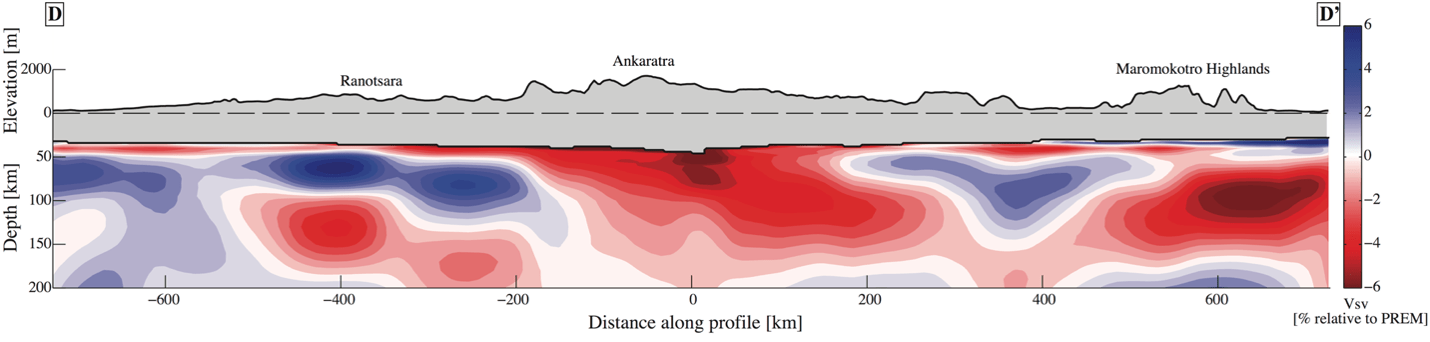
We deployed an array of 32 seismic stations over 2011-2012 to investigate the structure and seismotectonics of Madagascar and the surrounding region. Madagascar has curiously been the site Cenozoic hot spot intraplate volcanism, but the origin of which was unknown. We carried out an array of investigations of the seismicity, body-wave tomography, surface-wave tomography, and anisotropy (both P and S). Analyses show an extreme thinning of the crust and emplacement of 10 km of sediments along the western third of the island, where Madagascar rifted away from mainland Africa 150 million years ago. The crust is deepest along the central north-south spine of the island, but is also anomalous deep in the eastern third of the island and terminates abruptly along the eastern border, along which India slid northward 90 million years ago. Three areas of Cenozoic intraplate volcanism have occurred in Madagascar, in the north, center, and southwest of the island. Earth of these regions is underlain by a root of seismically slow, and therefore likely anomalously hot material. Surface wave tomography suggests that the subcrustal mantle lithosphere has begun to delaminate and is currently dipping toward the north, allowing hot asthenospheric rock to rise toward the surface. The significant central intraplate volcanism sits right atop the diagonal channel of low-velocity rock. The region of deep slow velocities in the north may be unrelated and due instead to a connection with the Comores hot spot. Previous studies have suggested the possibility of a tectonic plate boundary (of the Lwandle plate) passing through Madagascar, but a study of regional focal mechanisms does not support this hypothesis.
PI Team:
Michael Wysession and Douglas Wiens, Department of Earth and Planetary Sciences, Washington University, St. Louis, MO
Andrew Nyblade, Department of Geosciences, Penn State University, University Park, PA
Gerard Rambolamanan, Institute of Geophysics, University of Antananrivo, Madagascar
____________________________________________________________
SPREE (Superior Province Rifting EarthScope Experiment)
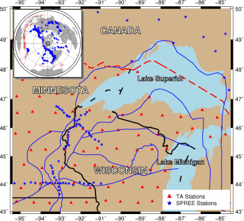
We installed a 84 broadband seismic stations from the EarthScope Flexible Array pool to explore the deep structure of the Mid-Continent Rift System (MCRS), the remnant of an extensive rifting event that failed to split the North American craton during the Mid-Proterozoic. How such rifts form and die, rather than developing into oceanic spreading centers, is unclear despite their key role in shaping the fabric of the continents. We have carried out an array of investigations involving receiver function analysis, seismicity, and tomographic inversions of body waves and surface waves (both earthquake-generated and from seismic noise). The MCRS shows slight thickening of up to 10 km along the ridge, consistent with a massive syntectonic volcanic event that may have emplaced as much as a million cubic kilometers of basaltic magma within the rift.
PI Team:
Suzan van der Lee, Donna Jurdy, Seth Stein (Dept Geological Sci., Northwestern University)
Andrew Frederiksen (Dept Geological Sci, University of Manitoba, Winnipeg)
Justin Revenaugh (Dept Geology and Geophysics, University of Minnesota, Minneapolis)
Fiona Darbyshire (Centre GEOTOP, University of Quebec, Montreal)
Douglas Wiens, Michael Wysession (Dept EPS, Washington University, St. Louis)
____________________________________________________________
Forensic Seismology: Military Explosion Source Identification

Caption: Example of vertical-component waveforms, (a) and (b), and their amplitude spectra, (c) and (d), from two car bombs in downtown Iraq (VBIED – vehicle-borne improvised explosion devices).
We helped install and have been involved with analyzing data from an array of seismometers in Iraq. This has provided us with multiple opportunities to study the seismic signals from various MOUT (military operations in urban terrain) sources that have included car bombs, the mortar attack and burning “cook-off” of a U.S. Air Force ammunitions depot, and the U.S. air strike of an Al Qaeda car bomb factory.
____________________________________________________________
Whole-Mantle Seismic Attenuation


We generated the first whole-mantle model of seismic shear-wave attenuation, and continue to develop means of looking at earth structure using seismic attenuation. The model VQM3D was made using 90,000 differential shear-wave attenuation measurements. A velocity model was simultaneously generated using the same data, and values were computed independently from radial and transverse data. The model shows a very strong correlation with the large-scale whole-mantle process of subduction. The Pacific and African megaplumes also show up as very broad regions of low Q.
____________________________________________________________
Water in the Lower Mantle
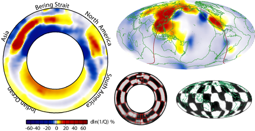
One of the most dramatic features in our global mantle shear-wave attenuation model is a very low-Q anomaly at the top of the lower mantle beneath eastern Asia. We believe that this is due to water that has been pumped into the lower mantle via the long history of the subduction of oceanic lithosphere in this region. This could result from the dehydration of hydrous phase D from cold lithosphere that has been subducted into the lower mantle.
____________________________________________________________
Missouri-to-Massachusetts (MOMA) IRIS PASSCAL Seismic Array
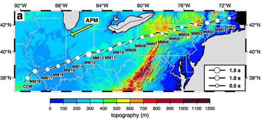
The Missouri-to-Massachusetts (MOMA) IRIS PASSCAL Broadband Deployment was jointly supervised by Karen Fischer, Michael Wysession, and Timothy Clarke, and involved the deployment of 18 broadband seismometers during 1/95 – 4/96. These stations were evenly spaced between permanent sites CCM (Cathedral Caves, Missouri) and HRV (Harvard, Massachusetts), providing a 20-station array spanning 1740 km with a 91.5 km average interstation distance. The scientific goal of the deployment was to closely examine at high resolution several different regions within the Earth using a single linear array of stations. This geometry provided excellent data yielding exciting new information about the structure of the core-mantle boundary, the seismic structure of the eastern U.S. crust and upper mantle, and the occurrence of seismic anisotropy at the top and bottom of the mantle.
____________________________________________________________
Florida-to-Edmonton (FLED) IRIS PASSCAL Seismic Array

During the Florida to Edmonton Broadband Seismometer Experiment (FLED), 28 broadband IRIS/PASSCAL STS-2 seismometers were deployed from central Florida to Alberta, Canada. Together with adjacent permanent stations from the IRIS/GSN, the USNSN the CNSN, and the New Madrid Seismic Network, the roughly linear array crossed diverse tectonic provinces and features, including the rifted continental margin, the Appalachian orogen, the Proterozoic and Archaean provinces of the continental interior, the Mid-Continent Rift and the Williston Basin. The portable stations were in the field from May, 2001 to October, 2002. These data yielded important information about mid-continent lithospheric structure, especially the thickening of the crust across the Mid-Continent Rift System, as well as information about the dispersion of core-diffracted waves.
____________________________________________________________
Diffracted Wave Dispersion
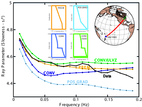
We developed a method to use the dispersion of core-diffracted Pdiff and Sdiff waves as a means of identifying the vertical velocity structure of the D′′ layer at the base of the mantle. When compared to synthetic seismograms, the method not only gives a measure of the mean velocity of the region of the CMB sampled, but also a measure of the vertical velocity structure of D′′, which is a very important and difficult-to-measure quantity.
____________________________________________________________
Variations in Vp/Vs at the Base of the Mantle
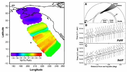
We examined variations in the Vp/Vs velocity ratio at the base of the mantle as an indicator of structure and composition there. MOMA slownesses of Pdiff and Sdiff phases showed large-scale D” lateral variations for both P (2%) and S (3%) waves. The sub-Alaskan core-mantle boundary region is unusual, with the study’s fastest S velocities (Vs) but slowest P velocities (Vp). The map shows the inferred variations in D” Vp/Vs found from the combination of Pdiff and Sdiff slowness residuals from western Pacific earthquakes recorded at MOMA. The huge drop in Vp/Vs beneath Alaska requires a non-thermal contribution such as from chemical heterogeneity or anisotropy.
____________________________________________________________
Radial Lower Mantle Shear-Wave Attenuation Model
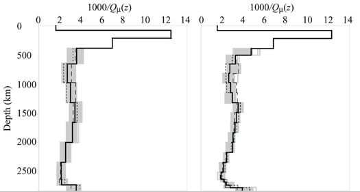
We obtained a radial model for shear-wave attenuation in the mantle. We employed a niching genetic algorithm to invert roughly 30,000 differential ScS/S attenuation values for a new radial quality factor (Q) model with high sensitivity to the lower mantle. The new radial Q model, QLM, possesses greater sensitivity to Q at great depths than previous studies. The model has two high-Q regions at ~1000 and ~2500 km depth, roughly corresponding to the high viscosity regions observed by Forte and Mitrovica [1996]. The best-fit radial model also has a lower-Q layer at the lowermost mantle. By relating Q to homologous temperature we infer a divergence of the lower mantle solidus and geotherm and a convergence within D”. Although large regional variations in Q certainly occur in the mantle, for applications such as geodynamic mantle flow models, radial models are still useful.
____________________________________________________________
Diffracted Wave Amplitude-Frequency Modeling
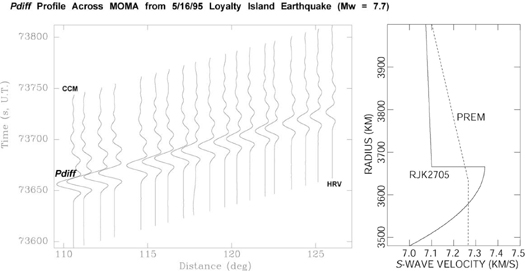
We analyzed the amplitude decay (as a function of frequency) of core-diffracted waves using PASSCAL array data as a means of examining the vertical velocity structure of the lowermost mantle. The frequency-dependent amplitude decay of MOMA Sdiff waves from a Kermadec earthquake provided evidence for a very thick (~200 km) thermal boundary layer above the eastern Pacific CMB. Modeling was also compatible with a region of lower seismic velocities lying directly above the thermal boundary layer. Although this model of discontinuity is usually identified with SdS and PdP waves, it also provided the best fit to the Sdiff amplitudes.
____________________________________________________________
Using ScS waves to Image the Lowermost Mantle
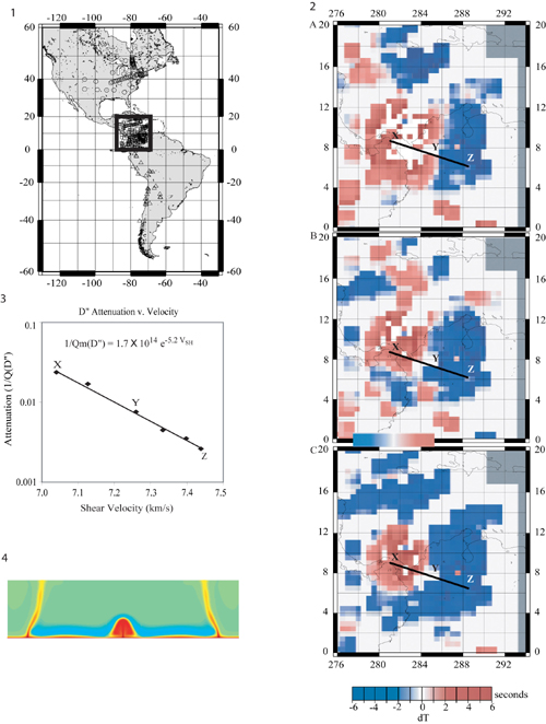
We have long been interested in using the reflections of ScS and PcP waves to map out lateral variations in the velocity structure of the D” layer at the base of the mantle. In the example shown here, South American earthquakes are recorded at the MOMA array and other North American stations, with the ScS bounce points beneath the western Caribbean Ocean. Top: The differential ScS-S travel times suggest a region of slow seismic shear velocities in the center of our region of sampling. Middle: The differential attenuation anomalies also suggest a region of high attenuation in the same location. Bottom: When the travel times are corrected using the differential delta-t* values, the region of low-velocity and low-Q becomes narrowed and focused. There is a log relationship between the attenuation and velocity, suggesting a thermal origin to the anomaly at the CMB. This kind of a feature has been modeled by Tan and Gurnis [2002] as a small incipient plume.
____________________________________________________________
Seismic Source Discrimination
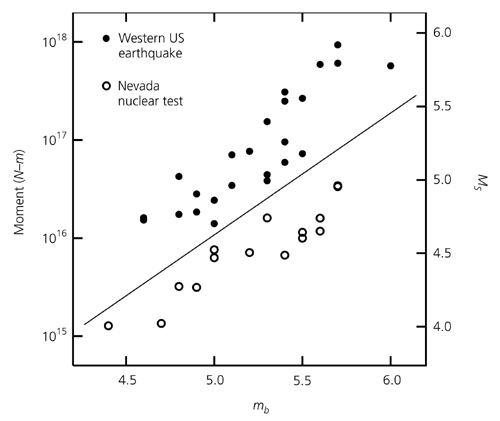
We used the amplitudes of Lg waves as a means of discriminating earthquakes from nuclear bombs. A genetic algorithm is used to determine both the Lg path attenuation and the source moment. As the diagram shows, the method clearly distinguishes Western U.S. earthquakes from Nevada nuclear tests.
____________________________________________________________
Lg Wave Attenuation From Earthquakes and Bombs
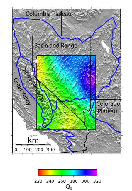
The Lg paths used in the previous study for nuclear source discrimination were also inverted to constrain the crustal attenuation in the Western United States. These studies support previous identifications of extremely low Q values beneath the Basin and Range region.
____________________________________________________________
The D” Discontinuity
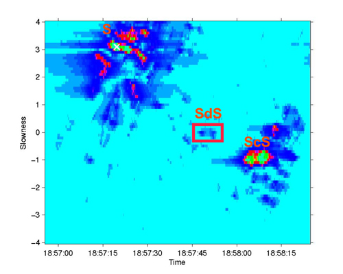
We used array processing techniques, such as this example of a slant-stack, or vespagram, in order to identify the locations of the D” discontinuity using ScS precursors recorded at PASSCAL arrays like MOMA and FLED. In this case, a very small D” discontinuity is identified on FLED array data for SdS waves reflecting off of the core in the vicinity of the Western Caribbean Ocean.